Ongoing Projects
Recent decadal-scale changes in land use/land cover in the Terai-Duar Savanna and Grasslands Ecoregion: Implications for terrestrial carbon cycling and plant biodiversity
Our first objective is to quantify the changes in Land Use / Land Cover in the last four decades for the entire region. This will allow us to view the overall trends and also present the spatial and temporal signature of these changes.
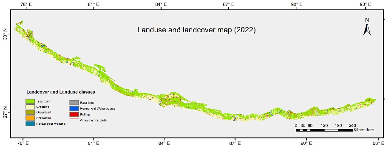
The Terai-Duar Savanna and Grasslands (TDSG) ecoregion, is relatively small in geographical extent, occupying only about 50,000 km2 in area. It also has an unusual shape, extending as a long narrow belt only 25 km wide, like a highly elongated rectangle bent in the shape of an arc. The northern extent is limited by the foothills, which forms a clear physical boundary. The southern edge, however, is diffuse and vulnerable to human intrusion, as most sites near and beyond the southern edge are densely populated agrarian settlements constantly pushing boundary of human influence to the north (see Figure below). This northerly push of human-caused disturbance and often actual encroachment constitutes a serious threat to the entire ecoregion.
Of the 50,208 km2 land area of TDSG only 9,900 km2 is protected as national parks, wildlife sanctuaries or tiger reserves (PAs). Tree cover accounts for 10,900 km2 area, and only half of this tree cover is located within PAs, implying the presence of significant area under grasslands. The savanna and grasslands appear to be restricted mainly to PAs, implying that such sites outside PAs have all been transformed. Historical records suggest that most of the agricultural expansion came at the expense of grasslands. Estimating grassland area is difficult as distinguishing grasslands from agricultural lands through remote sensing remains a challenge, not just in this region but across the world. Our preliminary estimate is that agricultural area is nearly 16,000 km. All told, it appears that only about 20% of the land area here may currently hold natural vegetation, which is low considering the ecological importance of the region. It is quite likely that there has been significant reduction in areas under natural ecosystems, even in recent decades. The causes and consequences of these changes are not well understood and this constitutes a critical knowledge gap for the ecology and economy of the region.
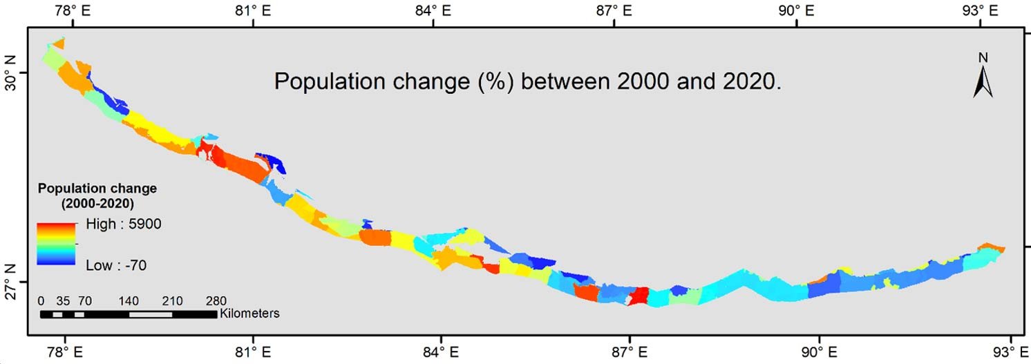
Hence our first objective is to quantify the changes in LULC in the last four decades for the entire region. This will allow us to view the overall trends and also present the spatial and temporal signature of these changes. Under this same objective we will also explore and build appropriate land use change models to understand the drivers and interactions that are responsible for these changes, including transitions between forest, savanna, and grassland. This has never been done at the scale of the entire ecoregion, and even smaller-scale analyses have only documented changes and have not undertaken land use change modelling to understand the roles of specific drivers and their interactions. For example, increases in population density in recent decades vary significantly across different parts of this ecoregion (See Figure below), as do climatic conditions, priorities for protection of wildlife and habitats, hydrological regimes, and a host of ecological and socioeconomic conditions. Under our first objective we plan to undertake a comprehensive assessment of these drivers and interactions. Next, we plan to understand how these LULC changes have affected the terrestrial carbon cycling for the entire ecoregion. Converting natural vegetation (forests, savanna, or grasslands) to cropland or other human-dominated land uses affects the aboveground biomass, and we need an ecoregion-wide analyses of these changes in recent decades. We plan to assess this using remote-sensing in combination with ground-based measurements.
Equally or more important is the impact of LULC changes on soil organic matter, which is far more complex to understand. The two broad components of SOM (POM and MAOM) have very different persistence, behaviour, and transformation rates. Added to this is the component of fire-derived organic matter, which can also show complex behaviour. There are reports of alarming decreases in topsoil organic carbon in agricultural land in recent years in the Nepal Terai, but there are hardly any comprehensive studies for the Indian Terai region. In the proposed work, we will use a rigorous study design involving four clusters of sites in the Indian part of TDSG, and we will measure the physical fractions of soil organic carbon in four LULC classes – forest, savanna, grassland, and agricultural land – in each of the four site clusters. We will have adequate replicates for each LULC class at each site at two soil depths, 0 -10 cm and 10 - 30 cm. Since measuring SOC dynamics is beyond the scope of this study, we cannot reliably estimate how SOC has changed under different LULC changes in recent decades. But the current patterns of SOC in different physical fractions can provide insight on the possible changes that have taken place and are likely to take place in the future. Using our extensive ground measurements in different parts of the TDSG ecoregion under different LULC classes, in combination with remote sensing data, we will estimate SOC for the entire ecoregion using predictive models. This is an important knowledge gap for the Indian part of the TDSG ecoregion.
Finally, we will link the observed patterns of plant diversity and vegetation structure with changes in land use and its effects on carbon pools in plant biomass and soils. These linkages are important given the complexity of vegetation formations that occur here, which has also not been explored fully across the TDSG ecoregion. LULC changes are expected to be strongly linked to biodiversity loss, but changes to biodiversity may also have strong impact on terrestrial carbon cycling through impacts on productivity and carbon inputs from leaf litter and root biomass.